
Serving the High Plains
Serving the High Plains
The Anniston Cemetery, which overlooks a hill near Highway 469 north of San Jon, remains the only evidence of the long-vanished town of Anniston. Quay County once counted about 80 towns during a boom-and-bust period about a century ago.
On a wall of the Quay County Clerk's office hangs a 1964 map of ghost towns in New Mexico.
The New Mexico Bureau of Mines and Mineral Resources compiled the map, of which copies are available from the office for a fee. In Quay County, the map shows about 20 ghost towns that might be unfamiliar even to longtime residents - towns with names such as Tipton, Revuelto, Canode, Adberg, Ard and Hanley.
It turns out the map far underestimated the number of defunct settlements in Quay County.
An examination of old and new maps, genealogy records, postal records, newspaper archives and local history books indicates the number of ghost towns in Quay County totals at least 80. And many of these villages disappeared more than a century ago. (See accompanying list.)
That many towns staggers the imagination when one considers the current day, when Quay County has just one city - Tucumcari - and only the villages of House, San Jon and Logan, plus one U.S. Census-designated place, Nara Visa.
The other current-day listed communities of Bard, Endee, Forrest, Glenrio, McAlister, Montoya, Quay and Wheatland arguably are ghost towns, as well, after becoming largely depopulated in recent decades.
Many longtime Quay County residents think the ongoing population drain began about 50 to 60 years ago. But the county experienced a boom-and-bust a century ago from which it never completely recovered.
Little traces exist of many of these ghost towns, but evidence of former settlements can found if you know where to look.
Boom and bust
White settlers existed in what now is Quay County since the 1850s in part because it laid on a caravan route between Santa Fe and Fort Smith, Arkansas. The region's population boom didn't occur until after the federal government opened up 5 million acres in New Mexico for settlement in 1902.
Sharecroppers, rental farmers and homesteaders looking to stake a claim flooded into the county. According to the U.S. Census, Quay County's population was 14,912 in 1910, just a couple of years before statehood.
By 1920, the county's population had declined 30%, to just over 10,000 people.
Local history books noted many of the county's new residents were farmers from the Midwest that were not prepared to deal with the region's arid climate. Many of those homesteads became abandoned less than a decade after they arrived.
While Quay County saw some population recovery up through the 1950s before declining again, it never again reached its 1910 peak.
Other towns also withered when new railroad lines bypassed them, prompting residents to move closer to the tracks.
Schools, more schools
An article in the Tucumcari newspaper in 1908 mentioned the county contained 86 school districts.
The article also stated the number of schoolchildren in the county ballooned from 320 in 1903 to more than 6,200 by 1908 - more evidence of the flood of new residents.
Quay County now counts only the school districts of Tucumcari, San Jon, House and Logan. Grady Municipal Schools sits in Curry County, but part of its district extends into Quay County.
Many of those closed schoolhouses have disappeared. The Wheatland school and gymnasium, constructed by the Works Progress Administration in 1939, still stand, as does McAlister's school.
One of the best preserved is Quay School, south of Tucumcari. Closed in 1955, it then was used for class reunions and other social events, but the last gathering was years ago.
However, one can easily imagine children frolicking on its playground after spilling out its front doors.
A one-room, wood-framed schoolhouse still stands as the only apparent survivor of the ghost town of Frost, with its slate blackboard still affixed on the length of one wall. The school closed in 1921. It sits near the Bard-Endee fire station on Highway 392, east of another ghost town, Porter.
Post offices
Another piece of evidence of the number of former settlements is post offices.
The history book "Quay County, New Mexico, 1903-1985" contains a listing of about 80 towns with post offices.
A perusal of that list shows many post offices went defunct before 1920, an indication of the rapid demise of many settlements or their consolidation.
One settlement, Brown, is listed as having a post office only from May 9, 1910, to January 1911 with the notation: "Never in operation."
Old stores
A few ghost towns still display evidence of their former vibrancy through the ruins of former businesses.
The old store at Ragland, closed since the 1960s, sits along Highway 209 as the road descends from the caprock.
The stone walls of the Porter Store in Porter continue to stand along Highway 392 after it closed decades ago.
Though a general store along Highway 252 in McAlister closed years ago, it is in good enough shape that one could imagine it reopening tomorrow.
Late former residents
Yet another indication of a former town is cemeteries. Where a town has disappeared, a nearby graveyard provides tangible evidence of its former residents.
The Genealogical Trails and New Mexico Tombstone Transcription Project websites each list nearly 40 cemeteries in Quay County, not counting family plots on ranches.
One striking cemetery is Montoya's along Route 66, which contains many graves decorated with keepsakes and Catholic saints - reflecting the town's former Spanish-speaking population.
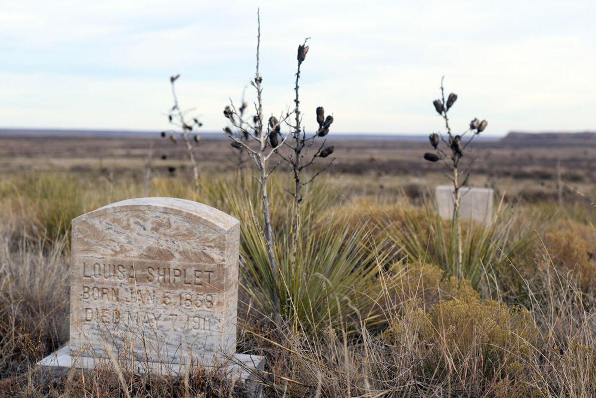
Anniston Cemetery, near Highway 469 north of San Jon, remains about the only evidence of the Anniston settlement. The graveyard sits on the side of a peaceful slope about a half-mile down a down a dirt road.
Name changes
Some towns proved indecisive on what name to settle on.
Bard changed its name to Bard City in 1909, then back to Bard in 1913.
Amego also was known as Amigo or Ahmigo before changing to Lockney.
The small settlement of Lesbia, southeast of Tucumcari, once was known as Castleberry.
Ragland, south of Tucumcari, formerly was known as Caprock.
Montoya once was known as Roundtree or Rountree.
One of the strangest name changes occurred when Looney postmaster Emma Stephenson, who disliked the town's name, in 1913 petitioned U.S. President Woodrow Wilson to change its name to Woodrow. Her petition was granted.
Moving on
A few ghost towns didn't stay in one place during their histories.
Endee, which remains one of the oldest settlements in Quay County, moved at least four times.
Bard moved three times.
In almost all cases, these towns moved because there was a more advantageous and potentially lucrative site nearby - a new railroad line in the early 20th century or the new U.S. 66 during the 1920s and '30s.
In short, they went to where the action was.
Ghost towns as tourism
The New Mexico Tourism Department, lists Montoya as a ghost town on its New Mexico True website.
Montoya holds the additional distinction of its Richardson Store, which operated from 1908 to 1980, being listed on the National Register of Historic Places. The long-closed building collapsed a few years ago, but tourists who travel Route 66 still stop to photograph it.
The main old Route 66 drag of the Texas-New Mexico border town of Glenrio, now holding fewer than 10 residents, has been listed on the National Register of Historic Places since 2007, despite the fact its motel, gas stations, post office and even a bar haven't been open for many years.
Writers and tour operators long have described Glenrio as a Route 66 ghost town - a symbol of what happens to some once-prosperous settlements when they're bypassed by the interstate.
Voting precincts
A notice about a county Republican convention in a 1910 Tucumcari newspaper listed 36 voting precincts in Quay County, including about 30 in now-depleted or defunct towns.
Tucumcari fielded seven delegates for the convention, and Montoya and Nara Visa each had three. Orton, Jordan, Murdock and Obar each had two.
The convention's purpose was to select five Quay County delegates for a constitutional convention in Santa Fe.
Sports success
A few now-depopulated towns once saw considerable success with their local sports teams.
The Porter Dragons, for instance, long were known as district contenders in boys basketball until the school went defunct in 1955.
But that success pales in comparison to the Forrest Pirates, which won state championships in boys hoops not just once, but twice. Coach W.S. "Bill" Wilson led his teams to state titles in 1931 and 1933, according to official records kept by the New Mexico Activities Association.
What's most impressive about the squad's accomplishments is they did it before New Mexico high school started a two-class system in the mid-1950s. That meant Forrest defeated far bigger schools en route to their championships.
An alphabetical list of vanished or nearly depopulated towns in Quay County by approximate location, whether it had a post office, whether it had a school and the approximate dates of both. Some data was not available.
• Adberg: six miles northeast of Tucumcari, post office, school
• Ahmigo (aka Amigo or Amego, changed to Lockney): 15 miles west of Nara Visa, post office 1908-1909
• Allen: 45 miles southeast of Tucumcari, post office 1906-1916, school circa 1907-1930s
• Antelope Flat: near Nara Visa
• Anniston: eight miles south of Logan, post office 1909-1913
• Apache: 35 miles southeast of Tucumcari, school 1917-1925
• Ard: southeast of McAlister, post office 1907-1913, school 1915-1921
• Arva: northwest of House, post office 1916-1918
• Barancos (aka Barrancas): 27 miles southeast of Tucumcari, post office 1905-1912, school 1907-1921
• Bard (aka Bard City): east of San Jon, post office 1908-1991, school 1908-1925
• Bashful Flats: near Nara Visa
• Brakes (aka Breaks): southwest of San Jon, post office 1907-1909
• Brown: northeast of McAlister, post office 1910-1911
• Canadian Flats: near Nara Visa
• Canode: six miles northeast of Logan, post office 1908-1914
• Cameron: southeast of Grady, post office 1908-1965
• Castleberry (changed to Lesbia): west of Tucumcari, post office 1910-1913
• Center (formerly Gill): school 1911-1934
• Cherokee Valley: 20 miles northeast of Nara Visa, school 1916-1923
• Clifford: northeast of Nara Visa, post office 1913-1919
• Collinsville: south of Ima, post office 1908-1912
• Cowan: south of Forrest, post office 1908-1912
• Cuneva: near Ima
• Curry: west of Jordan, post office 1907-1921
• Danley: post office 1917-1920
• Dodson: southwest of Tucumcari, post office 1901-1916, school 1903-1925
• Doris: southeast of Montoya, post office 1908-1913
• Douglas (later Tucumcari): post office 1901-1902
• Endee: east of San Jon, post office 1886-1955, school
• Fairview: school closed 1921
• Ford: northwest of House, post office 1907-1910
• Forrest: southeast of Tucumcari, post office 1908-1919, 1922-1969, school 1910-1966
• Frio (aka Frio View): east of Ragland, post office 1918-1922
• Frost: northeast of San Jon, post office 1909-1910, school 1908-1921
• Glenrio: 40 miles east of Tucumcari at Texas border, post office 1915-1995
• Grasshopper Flats: near Nara Visa
• Hanley: west of Tucumcari, post office 1907-1918, school until 1918
• Hargis: west of Tucumcari
• Harris: west of House
• Hartford: post office 1907-1910
• Hassell: northwest of House, post office 1907-1948
• Hogadero: west of Logan, post office 1884-1885
• Hudson (formerly Rice): between Logan and Tucumcari, post office 1908-1926, school closed in early 1920s
• Ima: 26 miles southwest of Tucumcari, post office 1908-1955, school closed early 1940s
• Jordan: southwest of Ragland, post office 1902-1955, school 1916-1925
• Kappus: south of Nara Visa, post office 1910-1913
• Kirk: five miles west of Forrest, post office 1908-1921
• Latimer: between Nara Visa and Obar, school 1910-1918
• Lesbia (formerly Castleberry): southeast of Tucumcari, post office 1913-1918
• Liberty: north of Tucumcari, post office 1880-1902
• Lockney: west of Nara Visa, post office 1909-1935, school consolidated 1926
• Locust Grove: near Ima
• Looney (changed to Woodrow): 31 miles southwest of Tucumcari, post office 1908-1918
• Long: near Porter, school closed 1921
• Lloyd (aka Loyd): south of Tucumcari, post office 1906-1914
• Lucille: northwest of House, post office 1911-1934
• Mater (aka Mater Switch): a few miles southwest of Logan
• McAlister: post office 1907-still operating, school closed 1956
• Mineosa: northwest of Nara Visa, post office 1908-1913
• Missouri Valley: five miles west of Obar/Perry
• Montoya: west of Tucumcari, post office 1902-1972, school 1903-1949
• Moore: south of Tucumcari, post office 1903-1912
• Murdock: northeast of McAlister, post office 1907-1917
• Norton: southeast of Tucumcari, post office 1907-1942, school started 1907, then later was consolidated
• Obar (formerly Perry): southwest of Nara Visa, post office 1908-1953
• Ogle Flat (aka Ogle): 14 miles southeast of Montoya, post office 1906-1913, school 1902-1926
• Orton (changed to Lucille): near Ima, post office 1908-1911
• Palomas: west of Tucumcari, post office 1907-1918
• Paradise Flats: near Nara Visa
• Perry (changed to Obar): southwest of Nara Visa, post office 1907-1908
• Plain: northeast of Forrest, post office 1907-1933, school until 1927
• Plaza: south of Tucumcari, post office 1908-1911
• Pleano: east of Forrest, post office 1907-1914
• Pleasant Valley: south of San Jon, school started 1906, consolidated to San Jon
• Porter: north of San Jon, post office 1908-1915, school 1916-1955
• Prairie Dell: near Porter, school 1908-1918
• Prairie View: southwest of Wheatland, post office 1908-1915
• Preston: west of Wheatland
• Puerto: 32 miles south of Tucumcari, post office 1901-1918, school 1902-1925
• Quay: south of Tucumcari, post office 1904-1995, school 1906-1955
• Ragland (formerly Caprock): post office 1908-1917
• Rana: northeast of Porter, post office 1908-1925, school until 1939
• Red River Springs (changed to Hogadero): post office 1878-1884
• Revuelto: west of San Jon, post office 1897-1916, school 1907-1930
• Rice (changed to Hudson): between Logan and Tucumcari, post office 1907-1908
• Rock Hill Flats: near Nara Visa
• Rock Island (changed to Glenrio): 40 miles east of Tucumcari, post office 1909-1915
• Roosevelt: five miles east of House, post office 1906-1919
• Roundtree (aka Rountree, changed to Montoya): 21 miles west of Tucumcari, post office 1901-1902
• Rudolph (changed to Castleberry): post office 1908-1910
• Ruth: near Ima
• Sand Springs: southwest of Nara Visa
• Shady Grove: north of San Jon
• Springer: south of Quay, school 1906-1927
• Sunny Knolls: near Obar
• Tipton: southeast of San Jon, post office 1909-1913, school
• Vigil: post office 1882-1882
• West: southwest of Tucumcari, post office 1908-1925, school 1908-1934
• Wheatland: south of San Jon, post office, school 1915-1950s
• Woodrow: west of Quay, post office 1913-1916